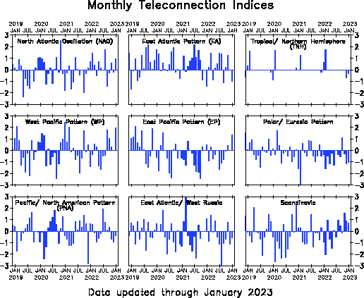
East Atlantic Index [EA index]
Teleconnective indices: East Atlantic Index [EA index]
The East Atlantic (EA) pattern is the second prominent mode of low-frequency
variability over the
North Atlantic, and appears as a leading mode in all months. The EA pattern is structurally
similar to the NAO, and consists of a north-south dipole of anomaly centers spanning the North
Atlantic from east to west. The anomaly centers of the EA pattern are displaced southeastward to
the approximate nodal lines of the NAO pattern. For this reason, the EA pattern is often interpreted
as a southward shifted NAO pattern. However, the lower-latitude center contains a strong subtropical
link in association with modulations in the subtropical ridge intensity and location. This subtropical
link makes the EA pattern distinct from its NAO counterpart. This EA pattern is similar to that
shown in the Barnston and Livezey (1987) study, but is distinctly different from the EA pattern
originally defined by Wallace and Gutzler (1981).
The positive phase of the EA pattern is associated with above-average surface temperatures
in Europe in all months, and with below-average temperatures over the southern U.S. during
January-May and in the north-central U.S. during July-October. It is also associated with
above-average precipitation over northern Europe and Scandinavia, and with below-average
precipitation across southern Europe.
The EA pattern exhibits very strong multi-decadal variability in the 1950-2004 record,
with the negative phase prevailing during much of 1950-1976, and the positive phase occurring
during much of 1977-2004. The positive phase of the EA pattern was particularly strong and
persistent during 1997-2004, when 3-month running mean values routinely averaged 1.0-2.0
standard deviations above normal.


Montly East Atlantic indices