North Pole stratosphere temperature
North Pole stratosphere: 10 hPa temperature (~ 30 km altitude)
The following graph compares the air temperature at 10 hPa at the North Pole
and the 1991-2020 average temperature. Observing the temperature at this stratospheric level,
corresponding to an altitude of about 30 km, is useful because there are possible repercussions
on the meteorology of the troposphere. It should be remembered that the stratosphere is the
second of the five layers into which the earth's atmosphere is conventionally divided, and that
its minimum polar altitude is about 8 km and extends up to about 50 km. At the equator
the stratosphere begins at about 20 km.
It is particularly interesting to identify sudden stratospheric warming (SSW)
and stratwarming which in their most intense form (major stratwarming)
can reach variations of 50/60 °C within a week.
In these cases it is possible to observe a rupture or split in two lobes of the
polar vortex, i.e. the high-altitude depression stationed on the pole (especially in winter)
and which is responsible for the descents of cold air towards the middle latitudes. Following the
split, an area of high pressure forms on the pole (with anomalous temperatures, above average
even in the troposphere) while the two lobes head south, causing bad weather conditions and
intense thermal decrease. This configuration was at the origin of the most intense frost waves
that hit the European continent (including Italy) in 1929, 1963, 1985, 2012, 2018. This atmospheric
configuration is completely temporary and reversible and the polar vortex can recompose after 15/20
days on the latitudes of its competence. Usually the effects of sudden stratospheric warming are
visible within a week.
It should be emphasized that a major warming does not always correspond to a weakening of the polar vortex.
At the same time, mid-latitude cold air outbursts are not always the result of stratwarming, but can
be caused by a weak El Niño
or by solar activity, both of which favor a weakening of the tropospheric polar vortex.
We also recommend consulting our page dedicated to the stratosphere
analysis, with diagrams useful for identifying stratwarming, the one dedicated to
temperatures and geopotential heights at 10 hPa, and finally the one dedicated to
temperatures and geopotentials at 100 hPa.
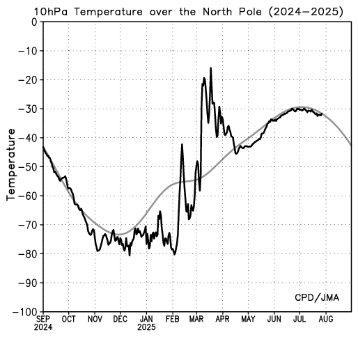
Credits: ds.data.jma.go.jp
North Pole stratosphere: 30 hPa temperature (~ 25 km altitude)
Another level useful for identifying stratwarming events is the one at 30 hPa. Here a comparison between the observed temperature and the 1991-2020 average is shown.
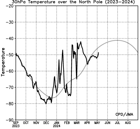
Credits: ds.data.jma.go.jp