Stratosphere analysis: looking for possible stratwarming events
Teleconnective indices - Stratosphere analysis (identification of stratwarming events)
This page contains some graphs and diagrams useful for identifying possible
stratwarming events, i.e. sudden and remarkable increase
of the
stratosphere temperature over the polar regions. The stratosphere is the second layer
of the atmosphere of the Earth, located above the troposphere and below the mesosphere that extends between about 15
and 60 km of altitude (see figure). The phenomenon is also known as Sudden Stratospheric Warming (SSW).
In some cases the westerly polar night jet disappears and easterly winds appear during the warming.
The warming is called a minor warming, when the polar temperature increases more than 25 degrees
in a period of a week or less at any stratospheric level.
If the zonal mean temperature increases poleward from 60 degrees latitude and the net zonal
mean zonal winds become easterly at 10 hPa (30 km) or below,
it is classified as a major. In a major SSW the sudden temperature heating is notable,
even +70 °C in a few days.
The increase in the temperature of the stratosphere can have repercussions on meteorological evolution,
particularly in the northern hemisphere. Stratwarming can result in a rupture
of the polar vortex with consequent irruptions of cold air towards mid-latitudes.
This event, labeled as major, is also anticipated by a change in the circulation of the
winds at high altitude (usually the pressure level is observed at 10 hPa, corresponding to
about 30 km of altitude). A shift of the polar vertex towards the mid-latitudes, with consequent thermal drop,
is also always part of the major events.
The SSW was discovered in 1952 by Scherhag[1], but it took some time (1971) before the mechanism was
theoretically identified by Matsuno[2]. The SSW is caused by a rapid amplification of planetary
waves propagating upward from the troposphere. Planetary waves deposit westward momentum and create
a strong meridional circulation which produces a large warming in the polar stratosphere due to
adiabatic heating (e.g., McIntyre 1982, [3]).
The split of the polar vortex involves the formation in the polar zone of a large area of
high pressure characterized by positive temperature anomalies, both in the troposphere
and in the stratosphere. At the same time, the two lobes originating from the split are heading south
(towards north in the southern hemisphere) bringing with them bad weather and falling temperatures.
The polar vortex split phenomenon preceded the largest cold outbreaks also observed in Italy,
but there is no direct correlation between observation of large colds and stratwarming events.
That is, it is possible that a frost wave is caused by other factors. One example above all was observed
in 1956, since the irruption of cold air was not preceded by SSW.
It usually takes 2-3 weeks for the polar vortex to heal.
[1]: Die explosionsartige Stratospharenerwarmung des
Spatwinters 1951/52, Ber. Deut. Wetterdienst 38, 51-63.
[2]: A dynamical model of the stratospheric sudden warming.
J. Atmos. Sci., 28, 1479-1494
[3]: How well do we understand the dynamics of
stratospheric warming? J. Meteor. Soc. Japan, 60, 37-65

Credits: ucsd.edu


Interaction between Stratosphere and Troposphere
The relationship between the stratosphere and the troposphere has widely been recognized.
During winter, tropospheric planetary waves propagate into the stratosphere along the westerly jet.
More recently, the converse relationship that the zonal mean zonal
wind anomalies slowly propagate from the subtropical upper stratosphere to the polar region of the
lower stratosphere and the troposphere during the boreal winter, is also noted.
It has been shown that SSWs occur in association with slowly propagating zonal mean zonal wind anomalies,
and the related changes in the troposphere exhibits the Annular Mode (AO)
like structure. Tthe downward propagation
of the AO from the stratosphere to the troposphere occurs in association with SSWs.
E-P Flux Analysis
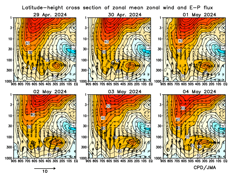
The stratospheric and the tropospheric circulation are connected with each other through wave mean flow interactions. The Eliassen-Palm (E-P) flux is widely used to characterize the wave activity. The direction of the E-P flux is proportional to the group velocity and indicates the direction of the propagation of the waves. Approximately, the vertical and horizontal components of the E-P flux are proportional to the eddy heat and momentum flux, respectively. The divergence of E-P flux is proportional to the northward flux of quasi-geostrophic potential vorticity, so that it is a direct measure of the total forcing of the zonal mean flow by eddies. Therefore, the E-P flux and its divergence are important and useful to diagnose planetary waves propagation as well as the effective mean zonal force induced by the waves.
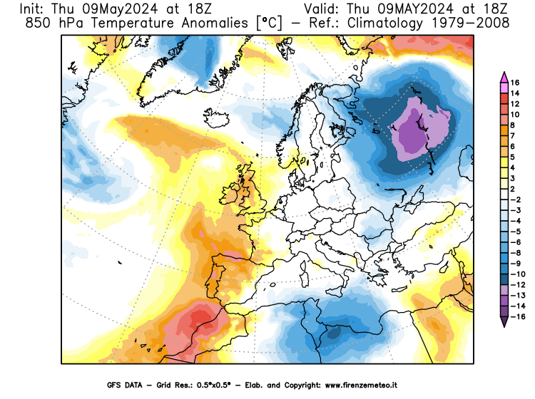
Polar Regions Temperatures - Analysis and Forecast
The following diagram, based on GFS analysis and forecast, shows observed and predicted temperature values on the polar regions (average between 60° N and 90° N) between 200 and 1 hPa.

Zonal winds 6 ° N - Analysis and forecast
In a free atmosphere and far from the friction forces of the earth's surface, the so-called
geostrophic wind is observed in good approximation. This is an ideal wind obtained in
stationary conditions from the equilibrium between the gradient forces (i.e. the force
that pushes the air between a center of high pressure and one of low pressure) and the Coriolis
force (that is, the force which in the northern hemisphere deflects motion to the right).
The geostrophic wind has a direction parallel to the isobars and in the northern hemisphere it
keeps the high pressure on its right.
The intensity of the geostrophic wind increases with latitude and with the horizontal pressure
gradient and decreases with increasing air density.
The zonal wind follows the lines of the parallels, forming latitudinal circles, in the west-east
direction. As written previously, SSW have been shown to occur in association with
mean zonal wind anomalies.
The following diagram, based on GFS analysis and forecast, shows observed and predicted zonal wind speeds
on the polar regions at 60° N between 200 and 1 hPa.

Credits: stratobserve.com
30-hPa temperature over the North/South Pole
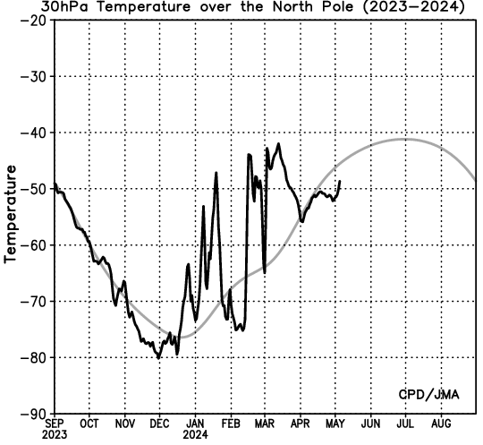

Credits: ds.data.jma.go.jp
10-hPa temperature over the North/South Pole
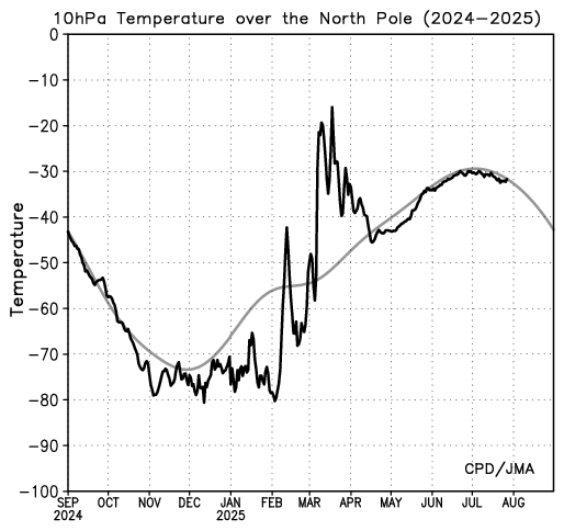
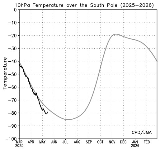
Credits: ds.data.jma.go.jp
Time-height cross section of zonal mean temperature
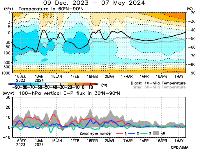
The black and gray lines on the top indicate 10-hPa and 30-hPa temperature, respectively. The gray shading on the bottom denotes the vertical components of E-P flux for whole zonal wave numbers, and the red, blue and green lines denote the vertical components of E-P flux for zonal wavenumbers 1, 2 and 3, respectively. The unit for the vertical component of E-P flux is m2/s2.
Credits: ds.data.jma.go.jp
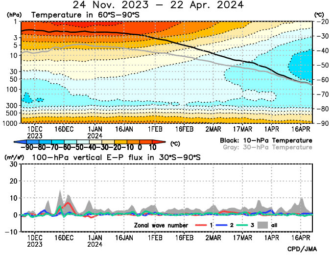
Zonal wind & Vertical components of 100-hPa E-P flux
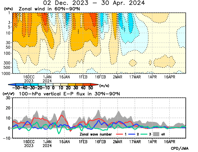
The gray shading on the bottom denotes the vertical components of E-P flux for whole zonal wave numbers, and the red, blue and green lines denote the vertical components of E-P flux for zonal wavenumbers 1, 2 and 3, respectively. The unit for the vertical component of E-P flux is m2/s2.
Credits: ds.data.jma.go.jp
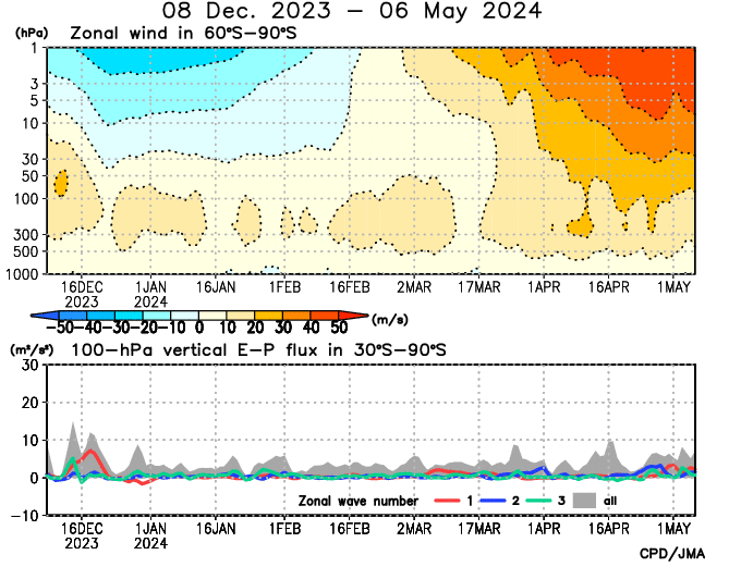
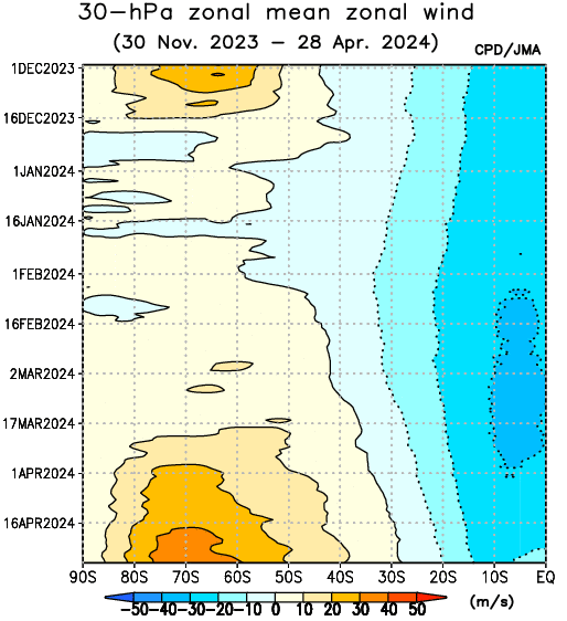
30-hPa zonal mean zonal wind
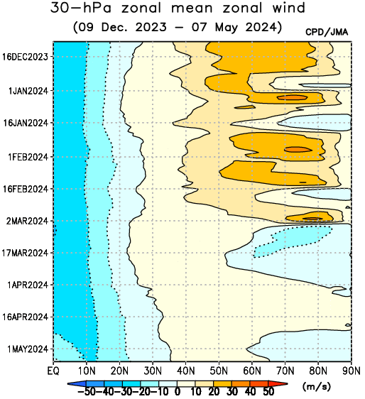
Credits: ds.data.jma.go.jp
Credits: ds.data.jma.go.jp
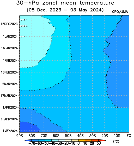
30-hPa zonal mean temperature
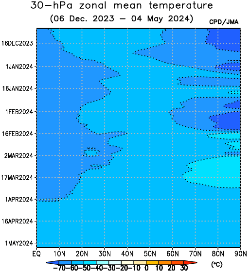
Credits: ds.data.jma.go.jp
Credits: ds.data.jma.go.jp
10-hPa zonal mean zonal wind

Credits: ds.data.jma.go.jp
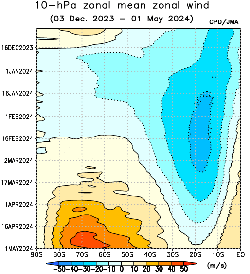
Credits: ds.data.jma.go.jp
10-hPa zonal mean temperature
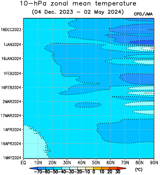
Credits: ds.data.jma.go.jp
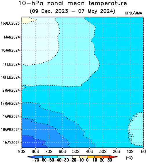
Credits: ds.data.jma.go.jp
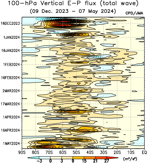
100-hPa Vertical E-P flux (total wave)
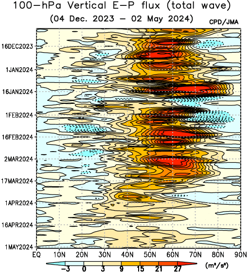
The contour interval is 6 m2/s2 (higher than 3m2/s2) and 3 m2/s2(lower than 3 m2/s2).
Credits: ds.data.jma.go.jp
The contour interval is 6 m2/s2 (higher than 3m2/s2) and 3 m2/s2(lower than 3 m2/s2).
Credits: ds.data.jma.go.jp
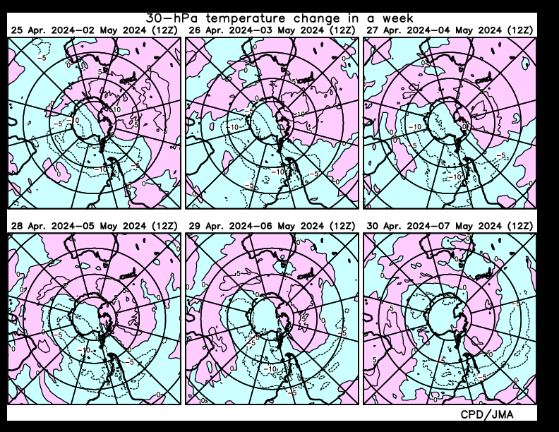
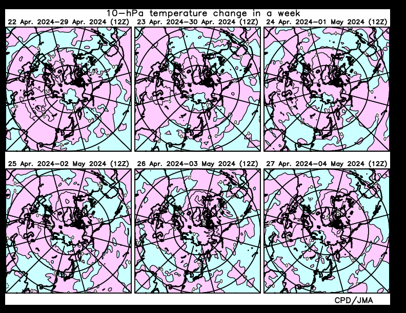
30-hPa temperature change in a week
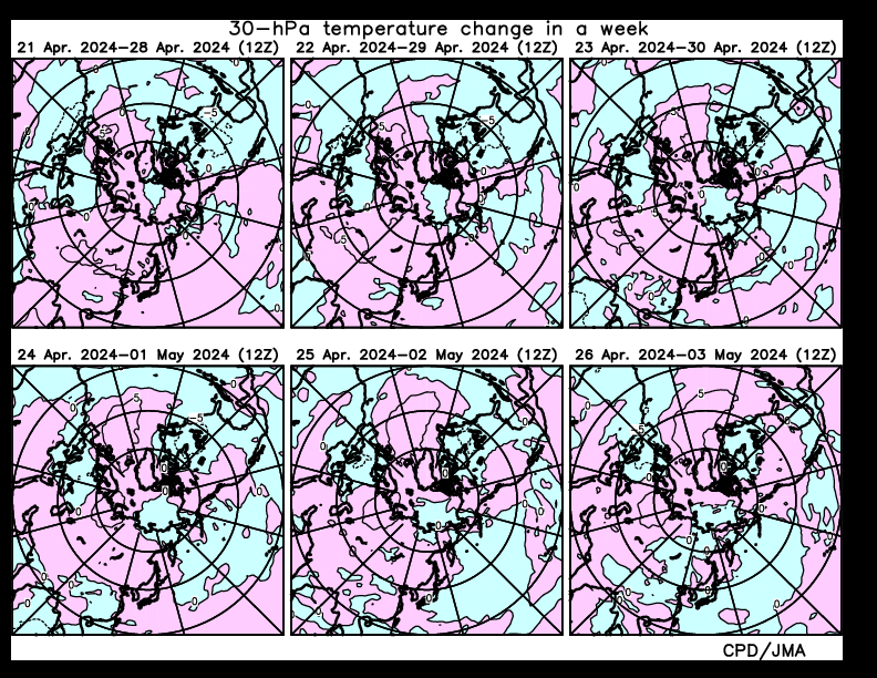
The contour interval is 5 °C. The pink and light blue shadings indicate warming and cooling, respectively. The red shading denotes warming for values higher than 25 °C.
Credits: ds.data.jma.go.jp
The contour interval is 5 °C. The pink and light blue shadings indicate warming and cooling, respectively. The red shading denotes warming for values higher than 25 °C.
Credits: ds.data.jma.go.jp
30-hPa temperature
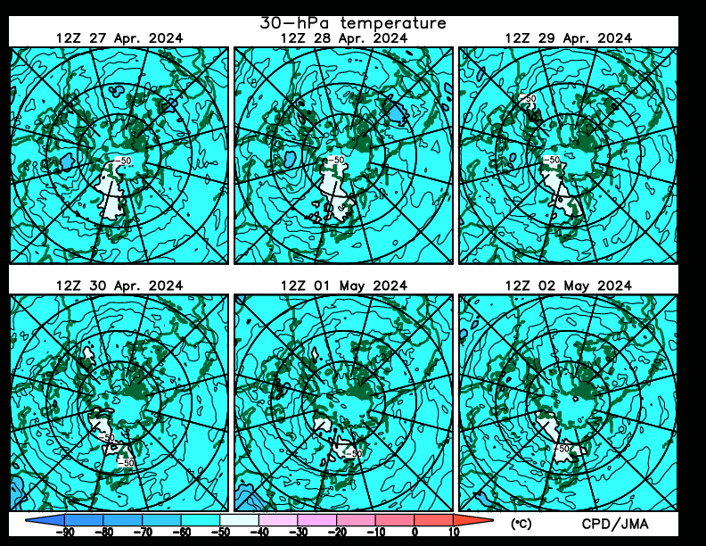
Credits: ds.data.jma.go.jp
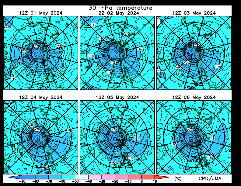
Credits: ds.data.jma.go.jp
30-hPa height
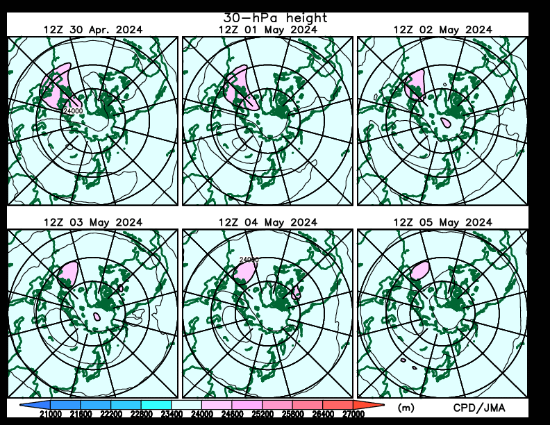
Credits: ds.data.jma.go.jp
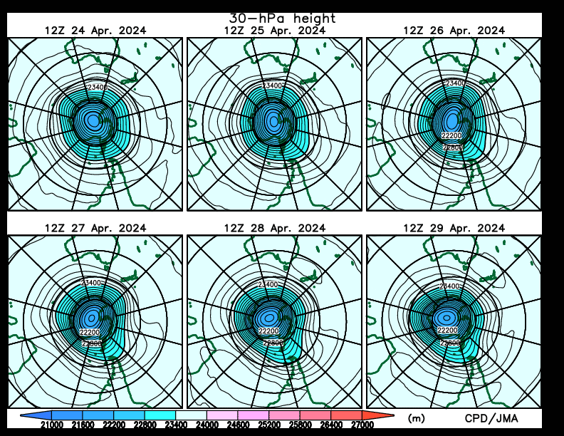
Credits: ds.data.jma.go.jp
10-hPa temperature change in a week
The contour interval is 5 °C. The pink and light blue shadings indicate warming and cooling, respectively. The red shading denotes warming for values higher than 25 °C.
Credits: ds.data.jma.go.jp
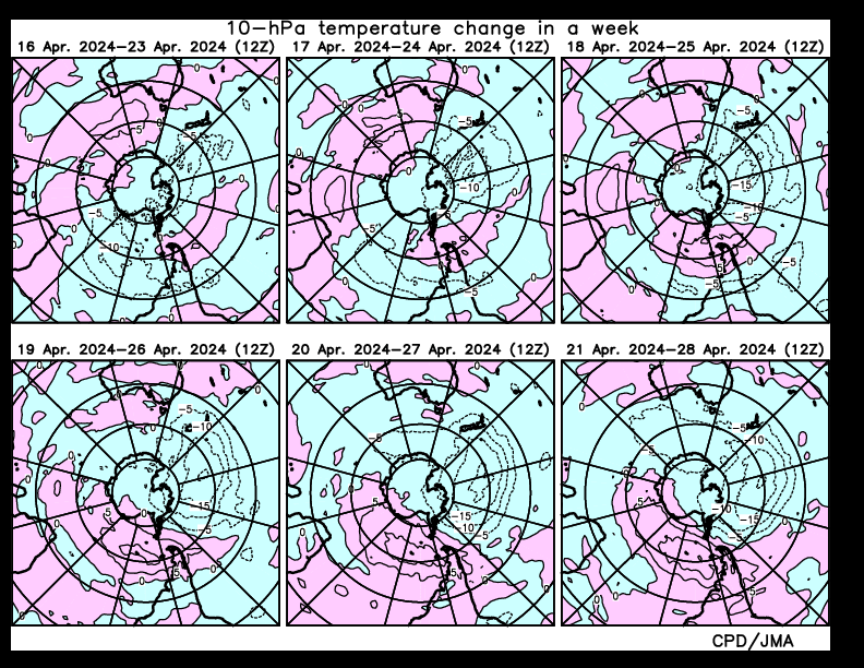
The contour interval is 5 °C. The pink and light blue shadings indicate warming and cooling, respectively. The red shading denotes warming for values higher than 25 °C.
Credits: ds.data.jma.go.jp
10-hPa temperature
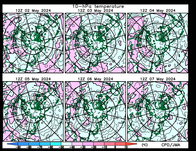
Credits: ds.data.jma.go.jp
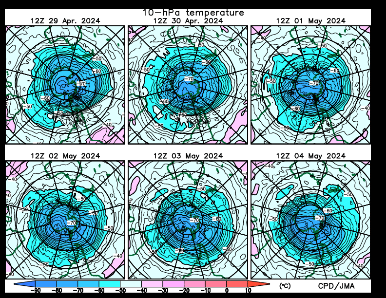
Credits: ds.data.jma.go.jp
10-hPa temperature
Credits: ds.data.jma.go.jp
Credits: ds.data.jma.go.jp
10-hPa height
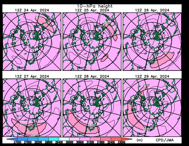
Credits: ds.data.jma.go.jp

Credits: ds.data.jma.go.jp
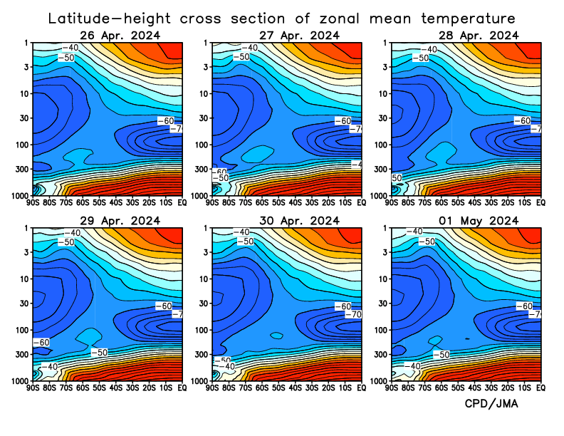
Latitude-height cross section of zonal mean temperature
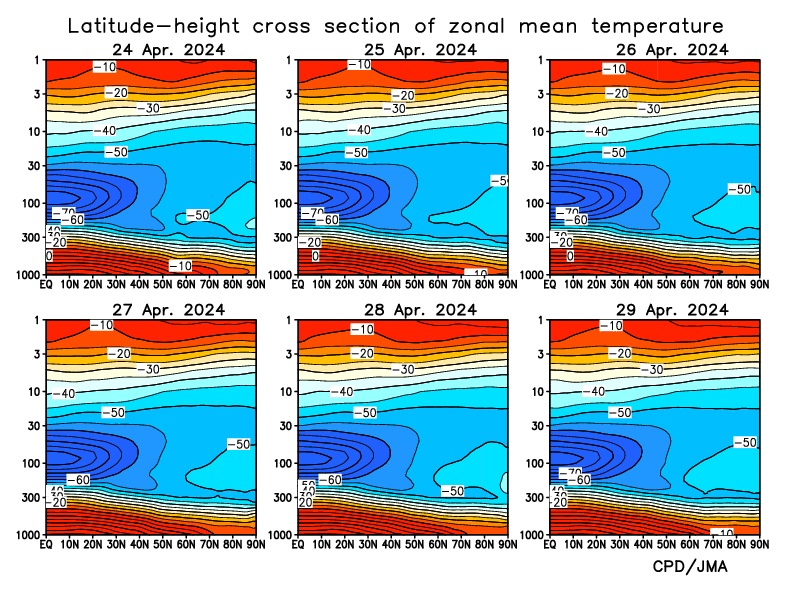
Credits: ds.data.jma.go.jp
Credits: ds.data.jma.go.jp
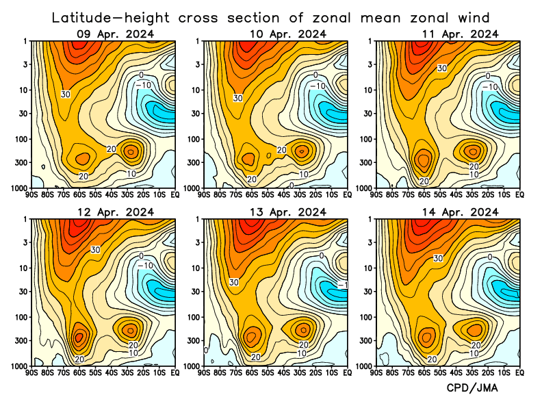
Latitude-height cross section of zonal mean wind
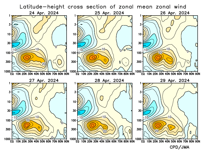
Credits: ds.data.jma.go.jp
Credits: ds.data.jma.go.jp
Latitude-height cross section of zonal mean zonal wind and E-P flux
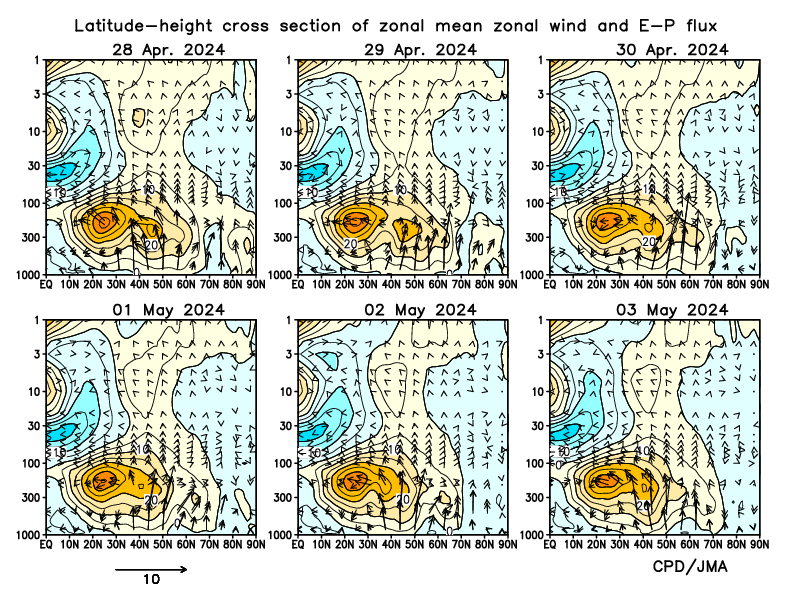
Credits: ds.data.jma.go.jp
Credits: ds.data.jma.go.jp