Madden-Julian Oscillation [MJO]
Teleconnective indices: Madden-Julian Oscillation [MJO]
The Madden-Julian Oscillation (MJO) is the largest element of intraseasonal
variability (30-90 days) in the tropical atmosphere. It is a large-scale coupling between atmospheric
circulation and deep tropical convection, and serves to localize tropical convective activity.
MJO indicates the eastward propagation of areas characterized by high convection near which
there are areas where strong compression prevails. This sort of wave moves eastward at around 6 m/s and
crosses the Indian Ocean and the Pacific Ocean in 30-60 days (it is only occasionally found in the Atlantic).
The points where compression/convection insist are defined as phases.
MJO diagrams: last 40/90 days values
The following diagrams illustrate the phase and intensity of MJO over the past 40/90 days.
Counterclockwise movement indicates a signal propagating eastward through 8 phases, from the
Indian Ocean to the Pacific Ocean and then over the Western Hemisphere. The colors of the lines
indicate different months, and the dates are noted. The further away from the center of the circle,
the greater the MJO. A high MJO value has effects on a planetary scale.
The Climate Prediction Center's (CPC) version of the daily MJO for the past 40 and 90 days
is nearly identical to the one used by the Australia Bureau of Meteorology Research Center (BMRC).
Slight differences can sometimes occur due to subtle deviations in input data and methodology,
and mostly occur during periods of weak MJOs.
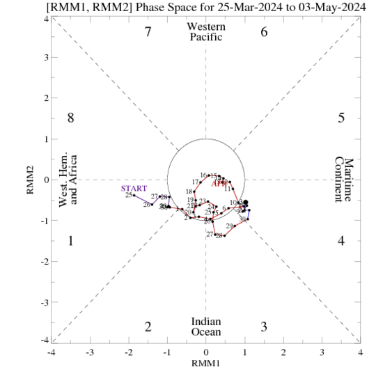
Credits: cpc.ncep.noaa.gov
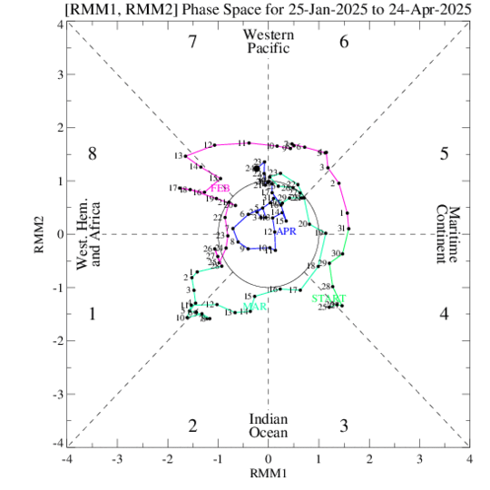
Credits: cpc.ncep.noaa.gov

Credits: bom.gov.au
MJO diagrams: last 8 years values
The following diagrams illustrate the amplitude of the MJO in the last 8 years.
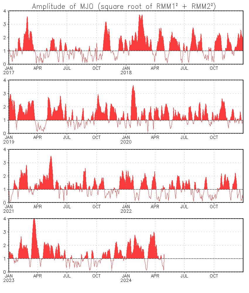
Credits: cpc.ncep.noaa.gov
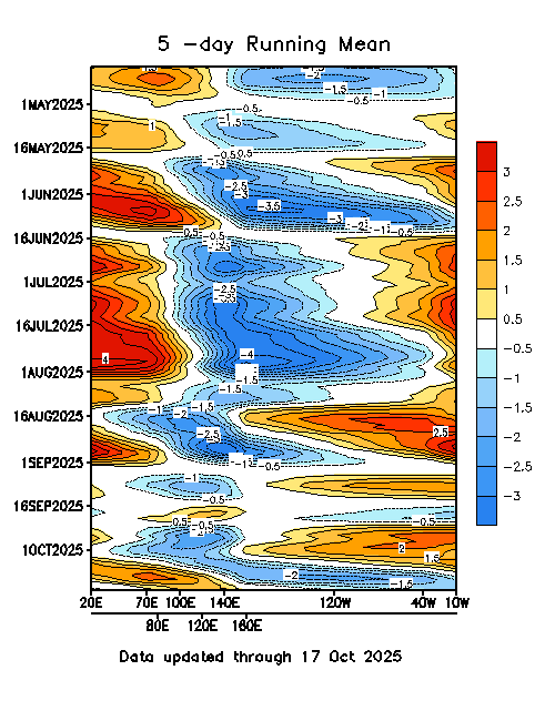
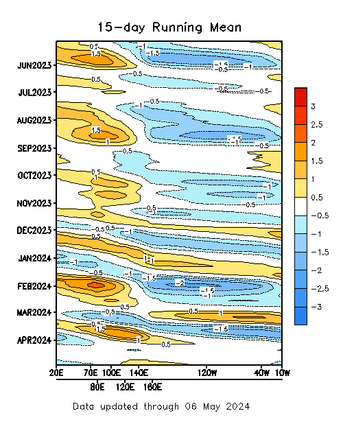
MJO diagrams: 5/15 day running mean
An extended Empirical Orthogonal Function (EEOF) analysis is applied to pentad velocity potential
at 200-hPa for ENSO-neutral and weak ENSO winters (November-April) during 1979-2000. The first EEOF
is composed of ten time-lagged patterns. We construct ten MJO indices by regressing the daily data
onto the ten patterns of the first EEOF. The figures below show the ten MJO indices (normalized) for
the previous 6 and 12 months.
Note that the blueish (reddish) color
represents the enhanced (suppressed ) convection, and the x-axis labels the centers (20° E, 70° E, 80° E,
100° E, 120° E, 140° E, 160° E, 120° W, 40° W and 10° W) of enhanced convection for the ten indices,
which are determined from the ten time-lagged patterns of the first EEOF of CHI200.
Credits: cpc.ncep.noaa.gov
Credits: cpc.ncep.noaa.gov
Madden-Julian Oscillation (MJO) forecast
Shown below are MJO forecast products using information from the ensemble GFS. Phase diagram showing the evolution of the last 40 days of observations along with the 15 day ensemble GFS forecast. The yellow lines are the twenty ensemble members and the green line is the ensemble mean (thick-week 1, thin-week 2). The dark gray shading depicts 90% of the members fall in this area and the light gray shading indicates 50% of the members.

Credits: cpc.ncep.noaa.gov
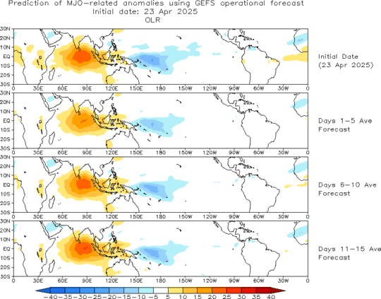
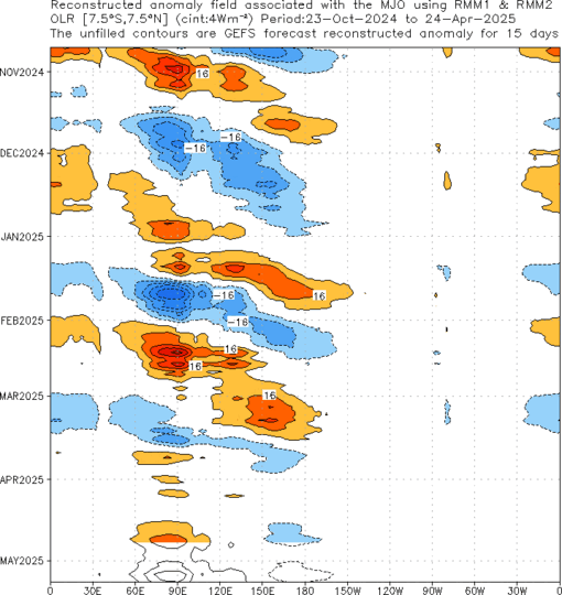
MJO: forecast associated at Outgoing Longwave Radiation (OLR)
In the next two diagram are shown the MJO forecast associated on anomalous
Outgoing Longwave Radiation (OLR).
In the first diagram a forecast of MJO associated anomalous OLR for the next 15 days
from the ensemble mean GFS based on forecasts of RMM1 and RMM2 is shown.
Blue (yellow/red) shades
show negative (positive) OLR anomalies and enhanced (suppressed) convection. Forecasts do not
include direct contributions from other climate modes such as ENSO, monsoons, etc. - only the MJO.
In the second diagram we can see a time-longitude section (7.5N-7.5S) of MJO associated anomalous OLR for the
last 180 days and for the next 15 days from the ensemble mean GFS based on RMM1 and RMM2.
Blue (yellow/red) shades show negative
(positive) OLR anomalies and enhanced (suppressed) convection. Forecasts do not include direct
contributions from other climate modes such as ENSO, monsoons, etc. - only the MJO.
Credits: cpc.ncep.noaa.gov
Credits: cpc.ncep.noaa.gov