Scandinavia Pattern [SCAND]
Teleconnective indices: Scandinavia Pattern [SCAND]
The Scandinavia pattern [SCAND] consists of a primary circulation center over
Scandinavia, with weaker centers of opposite sign over western Europe and eastern Russia/ western Mongolia.
The Scandinavia pattern has been previously referred to as the Eurasia-1 pattern by Barnston and Livezey
(1987). The positive phase (SCAND+) of this pattern is associated with positive height anomalies,
sometimes reflecting major blocking anticyclones, over Scandinavia and western Russia, while
the negative phase (SCAND+) of the pattern is associated with negative height anomalies
in these regions.
The positive phase of the Scandinavia pattern is associated with below-average temperatures
across central Russia and also over western Europe. It is also associated with above-average precipitation
across central and southern Europe, and below-average precipitation across Scandinavia.
![Scandinavia Pattern [SCAND], loading patterns](https://www.cpc.ncep.noaa.gov/data/teledoc/scand_correlation_map.gif)
Credits: cpc.ncep.noaa.gov
![Scandinavia Pattern [SCAND], correlation with temperatures](https://www.cpc.ncep.noaa.gov/data/teledoc/scand_tmap.gif)
Credits: cpc.ncep.noaa.gov
![Scandinavia Pattern [SCAND], correlation with precipitations](https://www.cpc.ncep.noaa.gov/data/teledoc/scand_pmap.gif)
Credits: cpc.ncep.noaa.gov
Montly SCAND indices
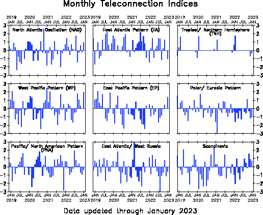
Montly SCAND indices
The Scandinavia pattern [SCAND] consists of a primary circulation center over
Scandinavia, with weaker centers of opposite sign over western Europe and eastern Russia/ western Mongolia.
The Scandinavia pattern has been previously referred to as the Eurasia-1 pattern by Barnston and Livezey
(1987). The positive phase (SCAND+) of this pattern is associated with positive height anomalies,
sometimes reflecting major blocking anticyclones, over Scandinavia and western Russia, while
the negative phase (SCAND+) of the pattern is associated with negative height anomalies
in these regions.
The positive phase of the Scandinavia pattern is associated with below-average temperatures
across central Russia and also over western Europe. It is also associated with above-average precipitation
across central and southern Europe, and below-average precipitation across Scandinavia.