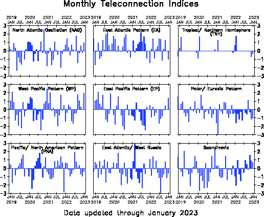
East Atlantic/Western Russia [EATL/WRUS index]


  Teleconnections and long range forecasts  
AAO (Antarctic Oscillation) NAM (North Annular Mode) SCAND (Scandinavia pattern) Stratosphere Analysis
AO (Arctic Oscillation) NAO (North Atlantic Oscillation) SOI (Southern Oscillation) North-Pole Stratosphere Temp
EA (East Atlantic) Polar/Eurasia SST (Sea Surface Temperature) 10 hPa Temp&Geop
EA/WR (East Atl./Western Russia) PNA (Pacific North-America) 100 hPa Temp&Geop
MJO (Madden Julian Oscillation) QBO (Quasi-Biennial Oscillation) Intraseasonal Oscillations


Teleconnective indices: East Atlantic/Western Russia Index [EATL/WRUS]

The East Atlantic/ West Russia (EATL/WRUS) pattern is one of three prominent teleconnection patterns that affects Eurasia throughout year. The East Atlantic/ West Russia pattern consists of four main anomaly centers. The positive phase (EATL/WRUS+) is associated with positive height anomalies located over Europe and northern China, and negative height anomalies located over the central North Atlantic and north of the Caspian Sea.
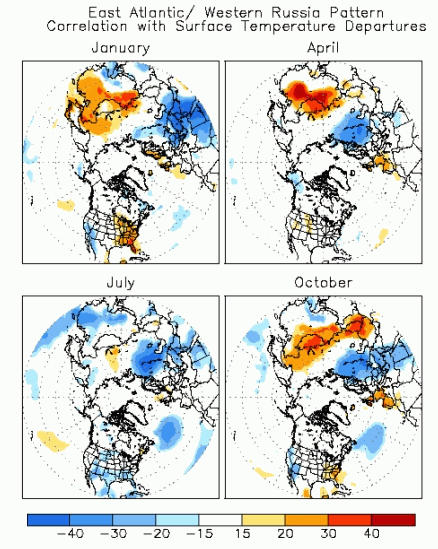
The main surface temperature anomalies associated with the positive phase of the EATL/ WRUS pattern reflect above-average temperatures over eastern Asia, and below-average temperatures over large portions of western Russia and northeastern Africa. 
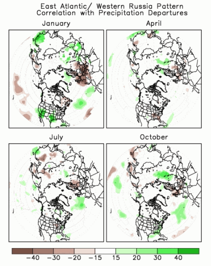
The main precipitation departures reflect generally above-average precipitation in eastern China and below-average precipitation across central Europe.

East Atlantic/Western Russia Index: correlation with temperatures
Maps showing correlation during 1950-2000 between the teleconnection index and monthly surface temperature departures for the three months centered on the month of interest. For example, the January pattern shows the correlation between the January values of the teleconnection index and the monthly temperature departures during December, January, and February.
Credits: cpc.ncep.noaa.gov
East Atlantic/Western Russia Index: correlation with precipitations
Maps showing correlation during 1950-2000 between the teleconnection index and monthly precipitation departures for the three months centered on the month of interest. For example, the January pattern shows the correlation between the January values of the teleconnection index and the monthly precipitation departures during December, January, and February.
Credits: cpc.ncep.noaa.gov

Montly East Atlantic/Western Russia indices

Montly East Atlantic/Western Russia indices
Montly Mean values of East Atlantic/Western Russia indices and other teleconnections. Credits: cpc.ncep.noaa.gov

Suggested sections

Webcams of the Alps

All the webcams of the Alps in a handy interactive map! Select the region, the province and select the location.

Webcam map of the Apennines

Consult the webcams installed along the Apennines using our interactive map to find the place of your interest!

GFS weather maps

Weather forecast issued by the GFS model (Global Forecast System) of the National Centers for Environmental Prediction (NCEP).

Earthquakes in real time in Italy

Maps and table with the latest earthquakes detected by the INGV monitoring system.